Volcanoes and life with them
Volcanoes have always provoked our admiration, but they play a fundamental role in our existence, from influencing the climate to causing great extinctions. Guatemala exists among volcanoes, and its past and present history is marked by them.
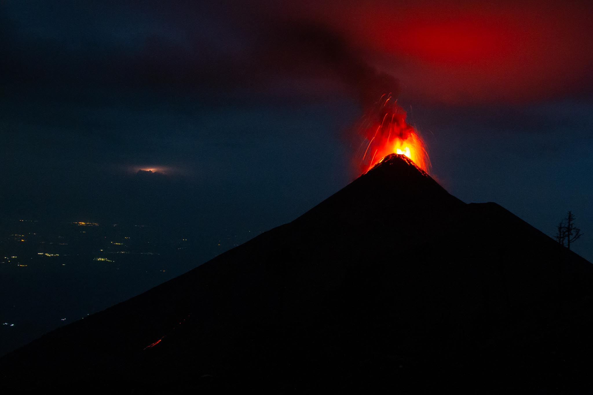
The Fire Volcano has been described since ancient times as one in constant activity. The June 3, 2018 eruption killed more than 300 people and injured several. The most affected places were the villages, hamlets and colonies surrounding the volcano, which were buried by the violent pyroclastic flows.
The Fire Volcano has been described since ancient times as one in constant activity. The June 3, 2018 eruption killed more than 300 people and injured several. The most affected places were the villages, hamlets and colonies surrounding the volcano, which were buried by the violent pyroclastic flows.

It is unknown how many thousands of years ago the Pacaya volcano first erupted, but at least 23 eruptions have been recorded since the time of Spanish colonization of America in Guatemala. Its activity is of the Strombolian and occasionally Plinian type.
It is unknown how many thousands of years ago the Pacaya volcano first erupted, but at least 23 eruptions have been recorded since the time of Spanish colonization of America in Guatemala. Its activity is of the Strombolian and occasionally Plinian type.

Magma flows from the interior of the Pacaya Volcano, located in the municipality of Amatitlán in the department of Guatemala and the municipality of San Vicente Pacaya in the department of Escuintla, Guatemala. Over the years, but recently in the years 2010 and 2020, this volcano has had powerful eruptions that have affected both nearby communities and the city.
Magma flows from the interior of the Pacaya Volcano, located in the municipality of Amatitlán in the department of Guatemala and the municipality of San Vicente Pacaya in the department of Escuintla, Guatemala. Over the years, but recently in the years 2010 and 2020, this volcano has had powerful eruptions that have affected both nearby communities and the city.

Tourists observe the lava rivers of the Pacaya Volcano. This is part of the Central American Volcanic Arc, a chain of volcanoes located along the Pacific coast of Central America, which was formed by the subduction of the Cocos plate under the Caribbean plate. It lies on the shore of a considerable caldera formed in the Pleistocene era that contains Lake Amatitlán. After being asleep for a century, it erupted violently in 1965 and has been in constant eruptive activity ever since.
Tourists observe the lava rivers of the Pacaya Volcano. This is part of the Central American Volcanic Arc, a chain of volcanoes located along the Pacific coast of Central America, which was formed by the subduction of the Cocos plate under the Caribbean plate. It lies on the shore of a considerable caldera formed in the Pleistocene era that contains Lake Amatitlán. After being asleep for a century, it erupted violently in 1965 and has been in constant eruptive activity ever since.

A strong eruption of the Volcán de Fuego in 2018 left such devastation that the neighboring landscape looked like something out of a scene from The Lord of the Rings. Photo: Jorge Rodríguez / Viatori

The vegetation in the El Rodeo village, located on the slopes of the Fuego volcano, was affected by the serious eruption that occurred in 2018. It is estimated that more than 1,200 human lives were lost during this event. Photo: Jorge Rodríguez / Viatori

The ash expelled by the Fuego volcano caused a small food crisis, since the crops for the subsistence of the families were seriously affected. Photo: Jorge Rodríguez / Viatori

The eruption of the Fuego volcano in 2018 seriously affected the crops located around the volcano. Thousands and thousands of dollars were lost in agricultural products, affecting hundreds of local families. Photo: Jorge Rodríguez / Viatori

An ash-covered passenger plane at La Aurora Airport in Guatemala City. On Thursday, May 27, 2010, the Pacaya volcano erupted. The ash column reached 1,500 meters high, affecting Guatemala City and 3 other departments of the Republic. It caused the closure of the capital airport, as this eruption produced a volcanic sand rain throughout the city, and the villages and communities of Escuintla and Sacatepéquez.
An ash-covered passenger plane at La Aurora Airport in Guatemala City. On Thursday, May 27, 2010, the Pacaya volcano erupted. The ash column reached 1,500 meters high, affecting Guatemala City and 3 other departments of the Republic. It caused the closure of the capital airport, as this eruption produced a volcanic sand rain throughout the city, and the villages and communities of Escuintla and Sacatepéquez.
 declared a red alert for the communities near the volcano, and recommended the evacuation of some of them. Since then it has had two powerful eruptions: one in 2014, and recently in 2021, which has caused lava flows to dangerously approach the communities settled on the slopes of the volcano, and which is affected every time it has activity.")
Neighbors clean the ash and volcanic sand from their roofs in the village of El Patrocinio, on the slopes of Pacaya. During the 2010 eruption, the National Coordinator for Disaster Reduction (CONRED) declared a red alert for the communities near the volcano, and recommended the evacuation of some of them. Since then it has had two powerful eruptions: one in 2014, and recently in 2021, which has caused lava flows to dangerously approach the communities settled on the slopes of the volcano, and which is affected every time it has activity.
Neighbors clean the ash and volcanic sand from their roofs in the village of El Patrocinio, on the slopes of Pacaya. During the 2010 eruption, the National Coordinator for Disaster Reduction (CONRED) declared a red alert for the communities near the volcano, and recommended the evacuation of some of them. Since then it has had two powerful eruptions: one in 2014, and recently in 2021, which has caused lava flows to dangerously approach the communities settled on the slopes of the volcano, and which is affected every time it has activity.

Interior view of one of the houses in the El Patrocinio village, in San Vicente Pacaya, affected by ashfall, volcanic rocks and pyroclastic flow. Despite the latent danger that living in a constantly erupting volcano means, many people from the various villages settled on the slopes of volcanoes such as Fuego and Pacaya, claim to have no other place to live, and return to the only ones homes they know. The same that they must clean and fix anew, with each new eruption.
Interior view of one of the houses in the El Patrocinio village, in San Vicente Pacaya, affected by ashfall, volcanic rocks and pyroclastic flow. Despite the latent danger that living in a constantly erupting volcano means, many people from the various villages settled on the slopes of volcanoes such as Fuego and Pacaya, claim to have no other place to live, and return to the only ones homes they know. The same that they must clean and fix anew, with each new eruption.

Neighbors of the El Patrocinio village in San Vicente Pacaya, evacuated their homes during the volcano's eruptive activity in 2010. They eventually returned to their homes settled on the slopes of Pacaya, only to experience new threats in 2014 and now in 2021. The history always repeats itself, such as the one that occurred in 1565. This eruption was one of the largest in Pacaya; since it was accompanied by strong earthquakes; It also had pyroclastic flows that destroyed everything around it. The damage to nature was very impressive as it must have cost the inhabitants a lot to get out of this calamity.
Neighbors of the El Patrocinio village in San Vicente Pacaya, evacuated their homes during the volcano's eruptive activity in 2010. They eventually returned to their homes settled on the slopes of Pacaya, only to experience new threats in 2014 and now in 2021. The history always repeats itself, such as the one that occurred in 1565. This eruption was one of the largest in Pacaya; since it was accompanied by strong earthquakes; It also had pyroclastic flows that destroyed everything around it. The damage to nature was very impressive as it must have cost the inhabitants a lot to get out of this calamity.
×